SUBSCRIBE & WIN! Sign up for the Daily CHAT News Today Newsletter for a chance to win a $75 South Country Co-op gift card!

Tornado emergency issued for Little Rock and nearby areas

Mar 31, 2023 | 1:54 PM

JACKSON, Miss. (AP) — The National Weather Service has issued a tornado emergency for Little Rock and surrounding areas, warning that 350,000 are in danger from a “confirmed large and destructive tornado.” Forecasters say the tornado was seen Friday afternoon in Little Rock and North Little Rock. There were no immediate reports of injuries.

THIS IS A BREAKING NEWS UPDATE. AP’s earlier story follows below.

JACKSON, Miss. (AP) — Massive storms brewing over at least 15 states in the Midwest and southern U.S. on Friday have meteorologists urging people to brace for dangerous weather including tornadoes, saying the conditions are similar to those a week ago that unleashed a devastating twister that killed at least 21 people in Mississippi.

More than 85 million people were under weather advisories Friday as the National Weather Service’s Storm Prediction Center forecast an unusually large outbreak of thunderstorms with the potential to cause hail, damaging wind gusts and strong tornadoes that could move for long distances over the ground.

Forecasters issued a tornado warning for parts of central and southwestern Arkansas on Friday afternoon after reports of a funnel cloud. Residents were told to take cover in basements and interior rooms away from windows.

Ping pong ball-sized hail was reported in Missouri, Arkansas and Iowa.

The area at greatest risk for storms on Friday follows a large stretch of the Mississippi River from Wisconsin all the way to Mississippi, with rare high-risk advisories centered around Memphis; and between Davenport, Iowa, and Quincy, Illinois and surrounding areas.

Forecasters issued tornado watches over both high-risk regions until Friday evening, with the weather service expecting numerous tornadoes and calling it a “particularly dangerous situation.”

All told, by Friday afternoon, tornado watches issued by the National Weather Service cover most of Missouri, Arkansas and Iowa; western Illinois; and parts of Wisconsin, Texas, Tennessee, Kentucky and Mississippi.

The “intense supercell thunderstorms ” predicted for Friday afternoon are only expected to become more common, especially in Southern states, as temperatures rise around the world.

The major population centers at high risk for storms starting Friday afternoon include Chicago; St. Louis; Little Rock and Jonesboro, Arkansas; and Des Moines and Cedar Rapids, Iowa.

“There will be lots of thunderstorms … tornadoes, damaging winds, and large hail,” said Northern Illinois meteorology professor and tornado expert Victor Gensini.

People in those areas should stock emergency supplies, prepare for power outages, avoid getting stranded in places vulnerable to falling trees or severe hail, and park vehicles in garages if possible, meteorologists said.

Forecasters warned of a “relatively rare, significant severe weather threat” around Chicago that could include powerful winds, tornadoes and large hail.

In Iowa City, the University of Iowa canceled Friday’s watch party for fans who planned to gather for the women’s basketball Final Four game against South Carolina. Deputy Director of Athletics Matt Henderson said in a statement the decision was made “due to the unpredictable timing of possible severe weather and potential storm impact.”

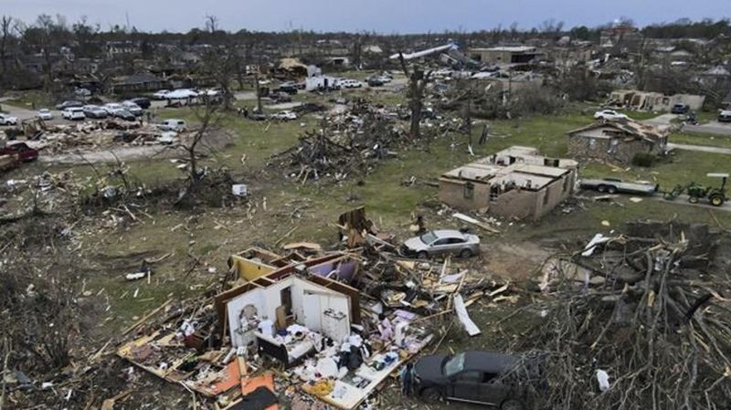
Last Friday night, a vicious tornado in Mississippi killed at least 21 people, injured dozens and flattened entire blocks as it carved a path of destruction for more than an hour. About 2,000 homes were damaged or destroyed, according to the Mississippi Emergency Management Agency.

The toll was especially steep in western Mississippi’s Sharkey County, where 13 people were killed in a county of 3,700 residents. Winds of up to 200 mph (322 kph) barreled through the rural farming town of Rolling Fork, reducing homes to piles of rubble, flipping cars and toppling the town’s water tower.

President Joe Biden and first lady Jill Biden are scheduled to visit Rolling Fork on Friday.

Gensini said Friday’s atmospheric setup is similar to the conditions that were present during Mississippi’s deadly storm.

The hazardous forecast is a result of strong southerly winds transporting copious amounts of moisture from the Gulf of Mexico north, where they will interact with the strengthening storm system.

In South Dakota, Gov. Kristi Noem ordered state executive branch offices to be closed Friday in parts of the state, as freezing rain, snow and high winds were expected. Many counties were under blizzard or ice storm warnings.

The weather service is forecasting another batch of intense storms next Tuesday in the same general area as last week. At least the first 10 days of April will be rough, Accuweather meteorologist Brandon Buckingham said earlier this week.

Bill Bunting, the weather service’s Storm Prediction Center chief of forecasting operations, said people need to have a severe weather plan in place that includes multiple ways to receive storm warning information.

“We’ve all seen the coverage of the heartbreaking situations in other parts of the country. Our fervent hope is that people pay attention to the forecasts that have been out for several days now regarding Friday’s threat,” Bunting said.

___

Baumann reported from Bellingham, Washington. Venhuizen reported from Madison, Wisconsin. AP writer Isabella O’Malley contributed from Philadelphia.

Michael Goldberg, Lisa Baumann And Harm Venhuizen, The Associated Press