SUBSCRIBE! Sign up for our daily newsletter and never miss a story!

Picture of the South Saskatchewan River taken at noon on June 2, 2026. (Image Credit: Jett Schwaier/CHAT News)
South Saskatchewan River (Updated)

City of Medicine Hat implementing precautions due to high river flow

Jun 2, 2026 | 11:14 AM

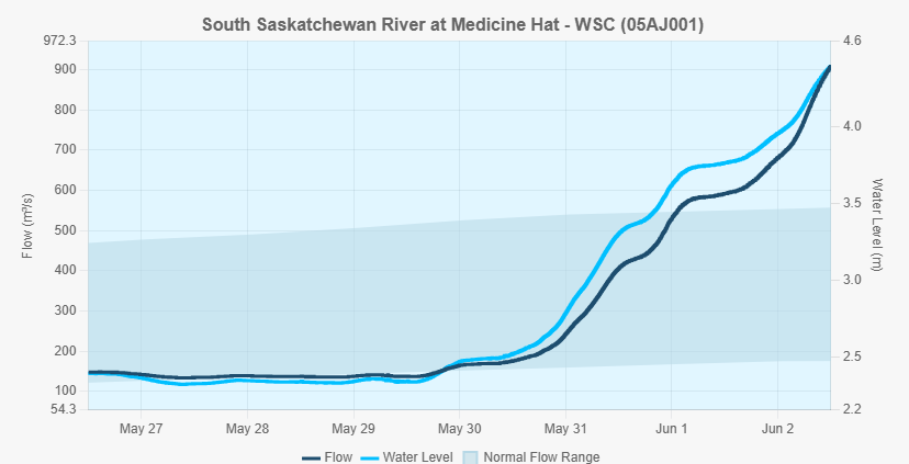
The City of Medicine Hat has temporarily closed some parks, boat launches and low-lying river pathways as a precaution due to rising river flow rates.

City officials announced the closures on Tuesday, saying the measures are being taken out of an abundance of caution as water levels increase. The city said that there is no anticipated risk of overland flooding or property damage.

Areas affected by the closures include Police Point Park, the Echo Dale Regional Park campground and all city boat launches, including those at Strathcona Island Park, Echo Dale Regional Park and Fire Station No. 1.

Several low-lying pathways along the South Saskatchewan River have also been closed, including trails in Strathcona Island Park and the Harlow and Riverside neighbourhoods, and Echo Dale Regional Park.

City crews have begun installing barricades and signage in affected areas. Residents are being asked to stay clear of work zones, obey closure notices and avoid river pathways that may be impacted by higher water levels.

The city said the current river flow rate is expected to increase over the coming days.

The current river flow rate listed on the government’s Alberta Rivers website at noon on Tuesday was 909 cubic metres per second, increasing significantly from the 137 cubic metres per second on Friday afternoon.

The river level has also risen over two metres from 2.34 metres on Friday to 4.39 metres on Tuesday at 10:30 a.m.

South Saskatchewan River flow rate and water level increases from rivers.alberta.ca up to noon on June 2, 2026.
South Saskatchewan River flow rate and water level increases from rivers.alberta.ca up to noon on June 2, 2026. (Image Credit: rivers.alberta.ca (Screenshot))

Officials noted that flow levels remain well below the about 5,200 cubic metres per second recorded during the devastating 2013 flood.

Local waterways, including Seven Persons Creek and Ross Creek, remain stable, according to the city. Officials also said there is no anticipated risk to the city’s water treatment plant, wastewater treatment plant or pump stations.

Medicine Hat officials expect conditions to return to normal by the middle of next week and said they continue to monitor river levels in coordination with the Alberta River Forecasting Centre.

The city said updates will be provided if conditions change.

As part of legislated annual emergency preparedness, the City of Medicine Hat conducted a large-scale emergency exercise last week, on May 27, to test how the community would respond to major flooding along the South Saskatchewan River.

READ: Full-scale emergency exercise conducted by City of Medicine Hat next Wednesday (May 22, 2026)